What makes a trail so special that it receives National Scenic designation? Well, according to the 1968 National Trails System Act, these 11 scenic trails are designated “for the conservation and enjoyment of the nationally significant, historic, natural, or cultural qualities.”
They may vary in length, structure, location and landscape, but what each of these trails share is a noble mission to maintain and preserve this country’s incredible, wild, natural lands for generations to come.
That being said, we thought it was important to get to know a little more about each of the 11 National Scenic Trails and why each of them is a significant part of our country’s diverse landscape.
New England National Scenic Trail
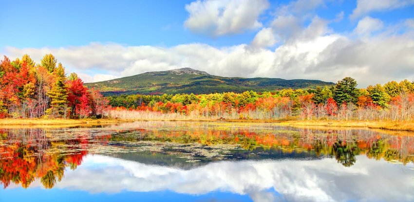
Although the New England Trail is considered an adolescent National Scenic Trail, the footpaths that construct this iconic trail system have been around for over half a century. The only National Scenic Trail exclusively in New England, the 215-mile New England Trail is comprised of the historic Mattabesett, Metacomet, and Monadnock Trail systems and travels from Long Island Sound in Connecticut to the Massachusetts/New Hampshire border.
The NET travels through characteristic New England countryside and features expansive vistas, forested valleys, rural towns, idyllic landscapes, and highlights a variety of diverse ecosystems. Accessible all year long, the NET is a perfect opportunity to connect with the New England’s incredible natural landscape.
Snappable Spots:
- The Seven Sisters - a section of summits in Massachusetts' Mount Holyoke Range. With an elevation change of 3700 feet, these peaks offer stunning vistas that are accented by red and orange foliage in the fall.
- Long Island Sound - where the saltwater of the Atlantic meets freshwater rivers, the trail touches the Sound at its very end (or beginning, depending on how you start).
Natchez Trace Trail

The Natchez Trace Trail follows sections of the Natchez Trace Parkway, an old 444-mile footpath that once connected Mississippi to Tennessee. Unlike other National Scenic Trails, the Natchez Trace Trail is not considered a contiguous trail but is made up of four distinct trails totaling approximately 70 miles: The Rocky Springs Trail, Tupelo Trail, Ridgeland Trail, and Leipers Fork Trail.
Walk sections of a preserved lifeline for the Old Southwest or take a drive through the nearby paved parkway to retrace the steps of American Indians, European settlers, slave traders, and soldiers that once walked the historic Natchez Trace.
Snappable Spots:
- Chickasaw Village Site - learn about the Native Americans who called this land home long before trails existed.
- Baker Bluff/Jackson Falls - this beautiful lookout point includes a scenic overlook and a short hike to a trickling falls.
The Potomac Heritage Trail
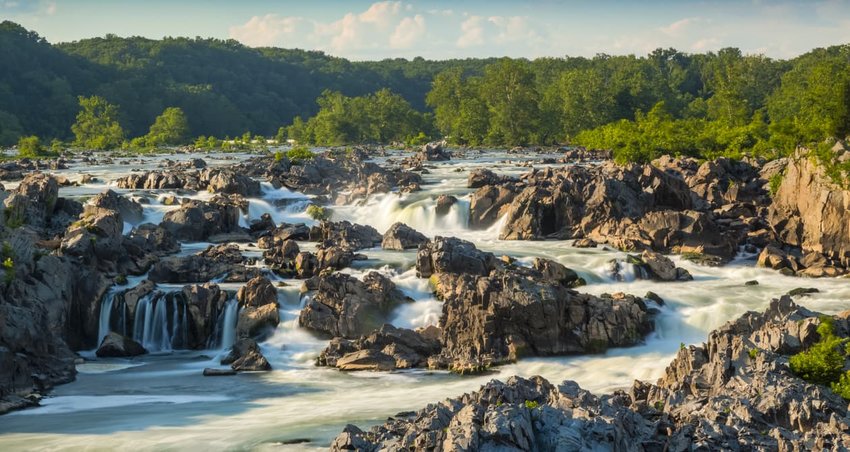
Established in 1983, the Potomac Heritage Trail consists of approximately 710 miles of interwoven trails and routes that highlight the diverse landscapes of the Chesapeake Bay and the Allegheny Plateau.
Unlike other National Scenic Trails, the PHT is not one contiguous trail, but a system of trails that run from the Potomac River and Pittsburgh, Pennsylvania through segments of Washington D.C., Maryland, Pennsylvania, and Virginia. This trail differs from many of the others in that you can experience it by boat, traversing the waterways that follow the footpaths.
Snappable Spots:
- The Great Falls of the Potomac - a swirling series of powerful rapids and sharp rocks, this section of the Potomac is worth a pic.
- Harpers Ferry National Historical Park - home to notable historic events (like John Brown's abolitionist uprising) and natural wonders, such as the convergence of the Potomac and Shenandoah Rivers, this park has plenty to explore.
Arizona Trail
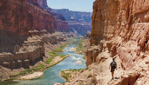
It may not be the longest, the oldest, or the most popular National Scenic Trail on the list, but the Arizona Trail is still highly revered as being a physically demanding, uniquely challenging, long-distance trail. Stretching across Arizona, from Mexico to Utah, only approximately 100 people thru-hike the trail each year.
Established in 2009, the AZT isn’t your everyday desert trail. Negotiating 800 miles of incredibly diverse landscape, hikers, bikers, trail runners, and equestrians traveling along the AZT traverse the largest contiguous ponderosa pine forest in North America, as well as other notable landmarks like Colossal Cave Mountain Park, Saguaro National Park, the Santa Catalina Mountains, and, the crowning jewel, the Grand Canyon. From vast plateaus to high elevation peaks, the Arizona Trail is sure to keep you guessing, what's around the next bend?
Snappable Spots:
- The Grand Canyon - the AZT traverses from rim to rim for incredible views of this natural phenomenon.
- Coconino National Forest - the largest contiguous ponderosa pine forest in North America, this forest stretches surrounds Flagstaff and Sedona in Northern Arizona.
Ice Age Trail
When you think of the Ice Age, Wisconsin probably isn’t the first place to come to mind. However, 12,000 years ago a massive flow of glacial ice carved out an incredible landscape across the state of Wisconsin. According to the Ice Age Trail Alliance, the Ice Age National Scenic Trail is a 1,200-mile footpath located entirely in Wisconsin that was crafted to highlight the unique features of this glacial phenomenon.
Connecting people and communities, more than a million people use the Ice Age Trail each year to hike, backpack, and snowshoe along the edge of the last continental glacier in Wisconsin. Traversing several state and federal lands, the Ice Age Trail consists of 600 miles of yellow-blazed routes and 500 miles of unmarked footpaths. So, if you’re looking to reconnect with nature, in an unassuming place, the Ice Age Trail is a great place to seek both solitude and spiritual revival.
Snappable Spots:
- Plover River Segment - follow wooden boardwalks through open prairie land and thick hardwood forest.
- Timm's Hill - the highest natural point in Wisconsin, this hill reaches an elevation of 1,951 feet.
- Kettle Moraine State Forest - featuring hilly terrain and glacial landforms, this forest includes hundreds of miles of trails.
Florida Trail
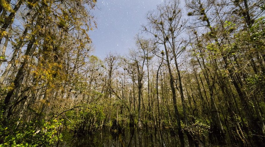
Florida’s longest and oldest recreational resource, the Florida Trail runs between Big Cypress National Preserve, north of the Everglades, to Gulf Islands National Seashore. Supported by a National Park on either side, this 1,448-mile footpath offers 198 trailheads that highlight incredible semi-tropical ecosystems, swamps, and beaches.
According to The Florida Trail, this legendary footpath was first conceptualized by a renowned wildlife photographer, Jim Kern, as Florida’s answer to the Appalachian Trail. Considered by locals to be the perfect place to “lose yourself in nature, while finding yourself,” thru-hikers can trek 1,101-miles from end to end, or section-hikers can jump on the trail at hundreds of access points scattered across nearby National Forests, Florida State Parks, or wildlife management areas.
Snappable Spots:
- Gulf Islands National Seashore - dip your toes in the sand as you hike through diverse coastal scenery.
- Drew Mansion Ruins - once the plantation home of Governor Drew during the post-Civil War Reconstruction period, the ruins are now open to picnickers.
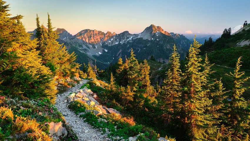
Pacific Northwest Trail

Oh, the Pacific Northwest, home to the towering Rockies, rolling grasslands, alpine meadows, and pristine sandy beaches; And nothing highlights the incredible diversity of the Pacific Northwest landscape quite like the Pacific Northwest Trail, a 1,200-mile continuous footpath that travels from the Continental Divide in Glacier National Park, Montana to the Pacific Ocean at Cape Alava in Olympic National Park.
The Pacific Northwest Trail Association estimates that only 40-50 people attempt to thru-hike the trail each year, a number that is steadily growing with increased interest in long-distance hiking. However, millions of section-hikers, day-hikers, and backpackers visit portions of the PNT, like Deception Pass State Park, each year.
Traversing seven National Forests, three National Parks, and six federally designated Wilderness areas, there’s a little bit of something, for everyone along the PNT.
Snappable Spots:
- Cape Alava - the westernmost point of the continental U.S., the cape marks the end of the trail in Washington.
- The Continental Divide - the "crown of the continent" this mountainous barrier separates the waterways that drain into the Pacific Ocean from those river systems that drain into the Atlantic Ocean.
- 3 National Parks - count them off: Glacier National Park, North Cascades National Park, Olympic National Park.
Pacific Crest Trail
You may recognize the Pacific Crest Trail as being the backdrop to the major motion picture, Wild. Much like the film, and its source material, thousands of hikers, backpackers, and equestrians section-hike or thru-hike the PCT each year, in search of solitude, self-discovery, and adventure.
A 2,650-mile continuous trail, the PCT travels from Mexico to Canada through California, Oregon, and Washington. At the top of the list with the Appalachian Trail in terms of popularity and prestige, this expansive, treasured footpath is known to feature the most beautiful, wild, and remote wilderness of the Western United States.
If you’re looking for panoramic vistas of volcanic peaks, unforgiving, remote desert terrain, or want to immerse yourself in glaciated regions tucked within the Sierra Nevada, the PCT should be at the top of your list.
Snappable Spots:
- Mojave Desert - the driest point in North America, this desert includes the famed Death Valley, along with a unique landscape of Joshua trees and sand.
- Lakes Galore! - the trail passes by three of the deepest lakes in the U.S. including Crater Lake, Lake Tahoe, and Lake Chelan.
- Mount Whitney - the highest summit in the continental U.S., this mountain peak has an elevation of 14,505 feet.
Continental Divide Trail
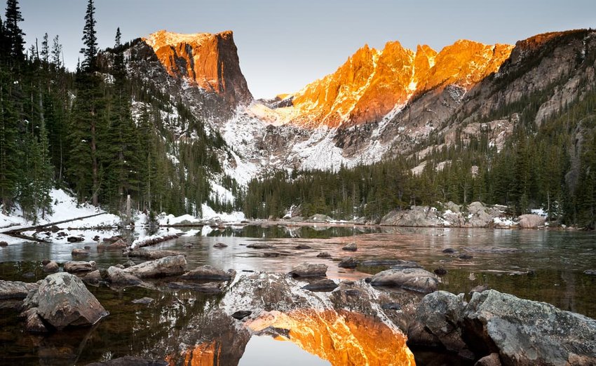
According to the Continental Divide Trail Coalition, the Continental Divide Trail is more than a line on the map--it’s a living museum of the American West. Stretching for an incredible 3,100 miles, the CDT travels from Mexico to Canada along the Continental Divide.
The CDT is considered one of the most significant conservation efforts in the U.S. and one of the most significant trail systems in the world. Arguably the most challenging thru-hike of the National Scenic Trails, it traverses five states, ranges from 4,000 to 14,000-feet in elevation, and passes through alpine tundra, broad glacial valleys, craggy mountain peaks, and desolate desert landscapes.
Sections of the CDT see thousands of visitors each year, but only approximately 150 determined backpackers attempt to complete it end-to-end.
Snappable Spots:
- Grays Peak - the highest point on any National Scenic Trail, reaching an elevation of 14,270 feet.
- Big Hatchet Mountains Wilderness Study Area - walk in the footsteps of Geronimo in this section of wilderness in New Mexico.
Appalachian Trail
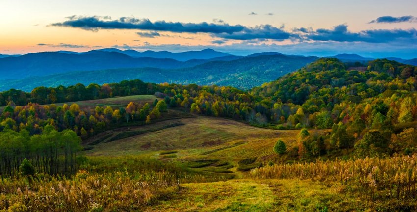
Known as “The People’s Trail,” the Appalachian Trail is one of the most iconic National Scenic Trails. Stretching for 2,200 miles from Springer Mountain, Georgia to Mount Katahdin, Maine, the A.T. is not only the longest hiking-only footpath in the world, but it also traverses 14 states and draws over 3 million people every year.
According to the Appalachian Trail Conservancy, approximately 3,000 people attempt to ‘thru-hike’ the entire trail in a single year, and only one in four actually complete it; making this infamous trek a relative rite of passage for long-distance thru-hikers. In fact, hiking the entire A.T. is the equivalent to climbing Mount Everest 16 times and takes 5-7 months to complete.
However, if you’re not quite ready to spend half a year on the trail, section-hiking the Appalachian Trail still guarantees an opportunity to immerse yourself in nature and guarantees an exhilarating and unforgettable experience.
Snappable Spots:
- McAfee Knob, Virginia - one of the most photographed points along the trail, this rocky ledge offers panoramic views of the surrounding valley and mountains.
- Blood Mountain, Georgia - the highest point on the AT, this mountain has a storied history in Cherokee legend.
- Grayson Highlands State Park, Virginia - spot herds of wild ponies along this beautiful section of the trail.
North Country Trail
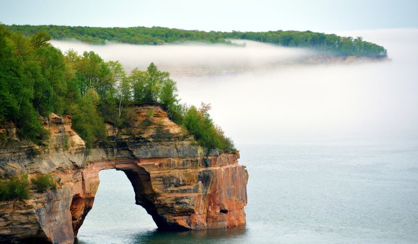
The North Country National Scenic Trail is a whopping 4,600 miles long making it the lengthiest in the National Trails System. The NCT passes through seven states from North Dakota to New York, ten National Forests, near three of the Great Lakes, and 150 federal, state, and local public lands.
Unlike other long-distance hiking trails in the National Trails System, the NCT’s incredible mileage and weather restrictions make completing a thru-hike almost impossible. In fact, according to the North Country Trail Association, only thirteen individuals have completed it end-to-end. Still, many people use the NCT for local day hiking, section-hiking, and backpacking.
Snappable Spots:
- Lake Superior - catch awesome views of this Great Lake along the cliffs of Michigan’s Pictured Rocks National Lakeshore.
- Finger Lakes Region - one of the most popular East Coast hiking areas, this region features a series of long, thin lakes along with several wineries for when you need a hiking break.
- Waterfalls — the Wisconsin section alone features several stunning waterfalls, including Superior Falls, Potato River Falls, Foster Falls, and Wren Falls.
Which Trail Should You Choose?
Our 11 National Scenic Trails are not only a distinct part of our history, but our future as a nation. Various coalitions, volunteers, trail angels, state and federal sectors work diligently to maintain and preserve these paths with hopes that they will “keep wild spaces wild for generations to come.” So, the next time you make plans to hit the trail, check in with a park ranger or ask around to see if you can add a National Scenic Trail to the list!
Want more information? REI put together an awesome, interactive map with more details on each trail, which you can view here.